
Archive Record
Images
Metadata
Object Name |
Map |
Catalog Number |
2010.019c.0003 |
Title |
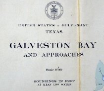
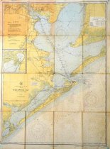
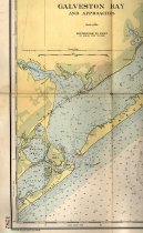
Map - USCGS Nautical Chart 1282: Galveston Bay and Approaches (1948) |
Search Terms |
Alexander Island Anahuac Atkinson Island Bay Ridge Bay Shore Park Baytown Bayview Bird Island Black Duck Bay Bolivar Peninsula Burnett Bay Carancahua Lake Chocolate Bay Chocolate Bayou Clear Creek Clear Lake Clifton BY the Sea Cold Pass Crystal Bay Deer Park Dickenson Dickinson Bayou Dollar Bay Dollar Point East Bay East La Porte Edwards Point Elmgrove Point Follett's Island Galveston Galveston Bay Galveston Channel Galveston Island Goose Creek Greens Lake Gulf of Mexico Halls Bayou Halls Lake Hanna Reef Houston Point Gulf Intracoastal Waterway Jones Lake Kemah Killkare Lake Stephenson League City Lone Oak Bayou Lynchburg Mayes Lake Morgan Point Moses Lake Mud Island Oaks Offatts Bayou Old River Lake Oyster Bay Oyster Lake Pasadena Peggy Lake Pelican Island Pelly Red Bluff Robinson Bayou Robinson Lake Round Lake Sake Surprise San Jacinto Bay San Leon San Luis Island San Luis Pass Scott Bay Seabrook Shoreacres Smith Point Spilmans Island Surf Oaks Swan Lake Sylvan Beach Tabbs Bay Texas City Titlum-Tatlum Bayou Titlum-Tatlum Island Todville Trinity Bay Trinity River Turtle Bay Turtle Bayou Turtle Bayou Vingtune Island |
Scope & Content |
Map USCGS Nautical Chart (1948) Chart 1282: Galveston Bay and Approaches Color lithograph on paper with pencil overwrite -----------------------TRANSCRIPT of TITLE BLOCK ------------ United States - Gulf Coast - Texas Galveston Bay and Approaches Scale 1:80,000 Soundings in feet at mean low water ---------------------------------------------------------- North arrow: yes (compass rose) North direction: top of map Compass bearings: no Scale: 1:80,000 |
Subjects |
Civil: - Anahuac - Bay Ridge - Bay Shore Park - Baytown - Bayview - Clifton BY the Sea - Deer Park - Dickenson - East La Porte - Galveston - Goose Creek - Kemah - Killkare - League City - Lynchburg - Morgan Point - Oaks - Pasadena - Pelly - Red Bluff - San Leon - Seabrook - Shoreacres - Surf Oaks - Sylvan Beach - Texas City - Todville - Turtle Bayou Islands/Peninsulas: - Alexander Island - Atkinson Island - Bird Island - Bolivar Peninsula - Dollar Point - Edwards Point - Elmgrove Point - Follett's Island - Galveston Island - Hanna Reef - Houston Point - Mud Island - Pelican Island - Red Bluff - San Luis Island - Smith Point - Spilmans Island - Titlum-Tatlum Island - Vingtune Island Waterways - Black Duck Bay - Burnett Bay - Carancahua Lake - Chocolate Bay - Chocolate Bayou - Clear Creek - Clear Lake - Cold Pass - Crystal Bay - Dickinson Bayou - Dollar Bay - East Bay - Galveston Bay - Galveston Channel - Greens Lake - Gulf of Mexico - Halls Bayou - Halls Lake - Intracoastal Waterway - Jones Lake - Lake Stephenson - Lone Oak Bayou - Mayes Lake - Moses Lake - Offatts Bayou - Old River Lake - Oyster Bay (now Christmas Bay) - Oyster Lake - Peggy Lake - Robinson Bayou - Robinson Lake - Round Lake - Sake Surprise - San Jacinto Bay - San Luis Pass - Scott Bay - Swan Lake - Tabbs Bay - Titlum-Tatlum Bayou (not labeled) - Trinity Bay - Trinity River - Turtle Bay - Turtle Bayou |
People |
Walker, John William |
Date |
1948 |
Dates of Creation |
1948 |
Year Range from |
1945 |
Year Range to |
1958 |
Extent of Description |
Paper: 34" wide x 45" high Image: 32" wide x 43" high |
Collection |
John Walker Collection |
Accession number |
2010.019c |
Other number |
USCGS 1282 |
Source |
John William Walker |
Credit line |
John William Walker |
Lexicon category |
8: Communication Artifact |
Catalog date |
2010-10-12 |
Catalog type |
Archive |
Imagefile |
024\2010.019c.0003-1.jpg |
Number of images |
3 |
Classification |
Documentary Artifact |
Received date |
Aug 2010 |