
Archive Record
Images
Metadata
Object Name |
Map |
Catalog Number |
1988.070c.0204 |
Title |
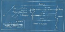
Map - South Texas Development Co. in Daniel Shipman & Charles Isaac Nidever Survey |
Search Terms |
Cedar Creek Linnville Bayou Linville Bayou San Bernard River Shipman & Nidever League South Texas Development Company |
Scope & Content |
Map Blueprint ---------------------------------------------------------------------------- Plat showing South Texas Development Co's Land in [Daniel] Shipman & Charles [Isaac Nidever] Survey Brazoria County, Texas Scale 1 in = 1000 var August 26, 1905 ---------------------------------------------------------------------------- North arrow: yes North direction: top of map clockwise 45 deg. Compass bearings: yes Scale: 1" = 1000 varas Scale unit: vara Prominent features: - Cedar Creek - Linville Bayou (aka Linnville Bayou) - San Bernard River |
Subjects |
Cedar Creek Linnville Bayou Linville Bayou San Bernard River Shipman & Nidever League South Texas Development Company |
People |
Bass, Nan Carson Charles, Isaac N. Garrett Gary McNeel Moore Nidever, Charles Isaac Robbins Rojen, C.J. Shipman, Daniel |
Date |
08/26/1905 |
Dates of Creation |
08/26/1905 |
Extent of Description |
Paper: 14" wide x 7" high Image: 13" wide x 6" high |
Collection |
Nan Bass |
Accession number |
1988.070c |
Other number |
1988-70-204 |
Source |
Nan Bass |
Credit line |
Nan Bass |
Lexicon category |
8: Communication Artifact |
Catalog type |
Map |
Condition |
Fair |
Imagefile |
007\1988.070c.0204.JPG |
Number of images |
1 |
Relation |
Show Related Records... |