
Archive Record
Images

Additional Images [3]
Metadata
Object Name |
Map |
Catalog Number |
2008.028c.0001 |
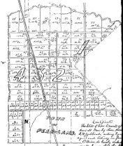
Title |
Plat Map - Pearland 09/26/1894 |
Search Terms |
Austin Street BNSF Brazoria County Courthouse Brazoria County Historical Museum Burlington Northern Santa Fe Galveston Avenue Gulf, Colorado, and Santa Fe Railroad Houston Tap and Brazoria Railway Orange Street Pearland, Texas Walnut Street |
Scope & Content |
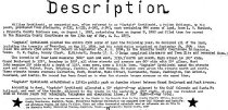
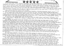
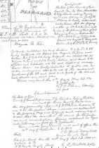
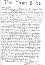
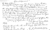
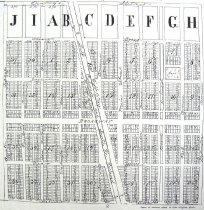
Plat Map Xerograph on Tyvek Pearland 09/26/1894 --------------------------------- TRANSCRIPT --------------------------- Pear Land Brazoria Co. Texas Sept. 26, 1894 ---------------------------------------------------------------------------------- North arrow: no North direction: top of map Compass bearings: yes Scale: 1" = 300 feet Scale unit: varas, feet Prominent Features - Abstract key map - Area bounded by: Orange Street Galveston Avenue Walnut Street Austin Street - Gulf, Colorado, and Santa Fe Railroad (now BNSF) - Platted townlots 1-40 - Typewritten historical notes - Handwritten land deed |
Subjects |
Austin Street BNSF Brazoria County Courthouse Brazoria County Historical Museum Burlington Northern Santa Fe Galveston Avenue Gulf, Colorado, and Santa Fe Railroad Houston Tap Brazoria Railway HTBRR Survey Orange Street Pear-Land Pearland Walnut Street |
People |
Christensen, S.M. Gayle, G.W. Mitchell, K. Murdock, L.W. O'Brien, J.W. Smith, Marguerite Massey Zychlinski, William |
Date |
09/26/1894 |
Dates of Creation |
09/26/1894 |
Year Range from |
1894 |
Year Range to |
1894 |
Extent of Description |
Medium: 36" wide x 24" high Image: 35" wide x 23" high |
Collection |
David Pettus |
Accession number |
2008.028c |
Source |
Found in collection |
Lexicon category |
8: Communication Artifact |
Catalog date |
2008-08-08 |
Catalog type |
Archive |
Imagefile |
022\2008.028c.0001-1.jpg |
Number of images |
9 |