
Archive Record
Images
Metadata
Object Name |
Drawing, Architectural |
Catalog Number |
2014.015c.0003 |
Title |
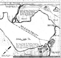
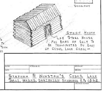
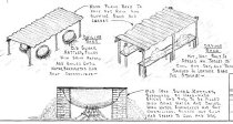
Floor plan of a proposed diorama of Cedar Lake Salt Works |
Search Terms |
Cedar Bayou Cedar Lake Cedar Lake Creek Evaporation Gulf of Mexico kettle Salt Salt factories Salt works |
Scope & Content |
Floor plan of a proposed diorama of Stephen P. Winston's Cedar Lake Salt Works, Destroyed November 25, 1862 Hand drawn pencil on translucent drafting paper Scale (of this drawing wrt to diorama) = 2" = 1' 0" North arrow (of this drawing wrt diorama) = yes North arrow (of diorama wrt drawing) = lower left corner of map. Historic features represented by diorama and shown on this drawing: - "Route of invading federal forces" - Beach (sand) - Cannon, small - Cedar Bayou - Cedar Lake #4 - Cedar Lake Creek - Gulf of Mexico - Rifle pit - Sand dune - Salt factories Also shown on this drawing are detail sketches of: - Boiling Shed (isometric) - Drying Shed (isometric) - Evaporation kettle with support structure (section) - Store House (isometric) |
People |
Winson, Stephen P. |
Year Range from |
1980 |
Year Range to |
2000 |
Extent of Description |
24" wide x 18" high |
Collection |
Found in Collection |
Accession number |
2014.015c |
Source |
Found in collection |
Lexicon category |
8: Communication Artifact |
Catalog date |
2014-09-19 |
Catalog type |
Archive |
Imagefile |
037\2014015c0003.JPG |
Number of images |
3 |