
Archive Record
Images
Metadata
Object Name |
Map |
Catalog Number |
2008.034c.0001 |
Title |
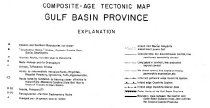
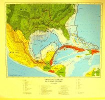
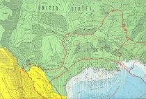
Map - Composite - Age Tectonic Map Gulf Basin Province |
Search Terms |
Bahamas Belize Colombia Cuba Dominican Republic El Salvador Geologic eras Geologic region boundaries Geologic sub-province boundaries Guatemala Haiti Honduras Jamaica Louisiana Geological Survey Mexico Nicaragua United States Venezuela |
Scope & Content |
Map Printed on paper in color ---------------------------------------------------------------------------------------------- Composite - Age Tectonic Map Gulf Basin Province Louisiana Geological Survey, E.G. Anderson, 1975 ---------------------------------------------------------------------------------------------- North arrow: no North direction: top of map Compass bearings: no Scale: 1:5,000,000 Scale unit: linear Prominent Features: - Country boundaries - Geologic eras - Geologic region boundaries - Geologic sub-province boundaries - Waters Countries represented: - Bahamas - Belize - Colombia - Cuba - Dominican Republic - El Salvador - Guatemala - Haiti - Honduras - Jamaica - Mexico - Nicaragua - United States - Venezuela |
Subjects |
Bahamas Belize Colombia Cuba Dominican Republic El Salvador Geologic eras Geologic region boundaries Geologic sub-province boundaries Guatemala Haiti Honduras Jamaica Louisiana Geological Survey Mexico Nicaragua United States Venezuela |
People |
Anderson, E.G. |
Date |
1975 |
Dates of Creation |
1975 |
Year Range from |
1975 |
Year Range to |
1975 |
Extent of Description |
Paper: 33" wide x 25" high Image: 24" wide x 24" high |
Collection |
BCHM |
Accession number |
2008.034c. |
Source |
Museum purchase |
Lexicon category |
8: Communication Artifact |
Catalog date |
2008-09-23 |
Catalog type |
Archive |
Imagefile |
022\2008.034c.0001-1.JPG |
Number of images |
3 |