
Archive Record
Images
Metadata
Object Name |
Map |
Catalog Number |
2012.028c.0001 |
Title |
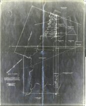
Map - J.F.Perry League No. 2 |
Search Terms |
Chocolate Bayou Corner Bayou CR171 FM2403 FM2917 Liverpool Pleasant Bayou SH35 St. Louis, Brownsville and Mexico Railway Houston Tap and Brazoria Railway |
Scope & Content |
Map Digital image of negative photostat J.F.Perry League No. 2 North arrow: yes North direction: top of map clockwise 43 deg. Compass bearings: yes Scale (original map): 1" = ~400 varas Scale (photostat): unknown ---------- TRANSCRIPT OF TITLE BLOCK ---------- Map showing replacement of the original survey of the S.F. Austin 1 3/ 4 Lg. Grant, Brazoria County, Texas Surveyed and Platted July 1937 E.S. Atkinson, C.E. Licensed State Land Sur. ----------------------------------------------- Civil: - Liverpool Townsite Transportation: - CR171 (not labeled) - FM2403 (not labeled) - FM2917 (not labeled) - SH35 (labeled "new state highway") - St. Louis, Brownsville, & Mexico Railway (now UPRR) Land parcels named on map: - Angier, Hall, & Bradley - Hooper & Wade No. 4 - Hooper & Wade - HT&BRR No. 5 - Perry & Austin Lg. No. 7 - Stephen F. Austin - William Harris Transportation: - CR171 (not labeled) - FM2403 (not labeled) - FM2917 (not labeled) - SH35 (labeled "new state highway") - St. Louis, Brownsville, & Mexico Railway (now UPRR) Waterways: - Chocolate Bayou - Corner Bayou - Pleasant Bayou - Small stream |
People |
Angier Atkinson, E.S. Austin, Stephen Fuller Bradley Hall Harris, William Hooper Perry, James Franklin Wade |
Date |
July 1937 |
Dates of Creation |
July 1937 |
Extent of Description |
17" wide x 21.5" high |
Collection |
Brazoria County District Court |
Accession number |
2012.028c |
Lexicon category |
8: Communication Artifact |
Catalog date |
2012-07-24 |
Catalog type |
Archive |
Imagefile |
028\2012028c0001.JPG |
Number of images |
1 |