
Archive Record
Images
Metadata
Object Name |
Map |
Catalog Number |
1988.070c.0194 |
Title |
Map - Columbia (East Columbia and West Columbia) |
Search Terms |
Bell's Landing Brazoria County Abstract Company Brazos Avenue Brazos River CR437 CR468 CR646 CR703 East Columbia FM1301 FM2852 International & Great Northern Railroad SH35 Varner Creek |
Scope & Content |
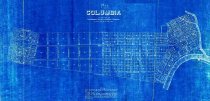
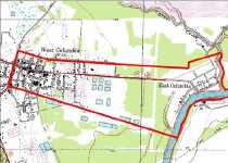
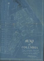
Map Blueprint --------------------- TRANSCRIPT OF TITLE BLOCK ---------------------- Map of COLUMBIA Compiled by the Brazoria County Abstract Company Scale - 400 ft. to one inch -------------------------------------------------------------------------------------------- NOTE - The portion of the above town lying west of Fourteenth Street is known as "West Columbia". The above map is a copy of an old map in the possession of one of the early settlers of Columbia, and we believe that it is correct. Drawn by Frank K. Stevens --------------------------------------------------------------------------------------------- North arrow: yes North direction: top of map Compass bearings: yes Scale: 1" = 400 feet Scale unit: feet Prominent Features: - Brazos River - East Columbia townsite - Ferry (Bell's landing?) - IGNRR western terminus (no longer extant) - Street rights-of-way (see lists below) - Varner Creek - West Columbia Plaza (no longer extant or never built) - West Columbia townsite Streets in West Columbia: - Bernard Street - Brazos Avenue (SH35/FM1301) - Clay Street - Eighteenth Street - Eleventh Street - Fifteenth Street - Fourteenth Street - Hamilton Street - Jackson Street - Jefferson Street - Seventeenth Street (SH35) - Sixteenth Street - Thirteenth Street (FM2852 - Twelfth Street Streets in East Columbia: - Austin Street - Bell Street (ROW only) - Bridge street (ROW only) - Commerce Street (ROW only; now SH35 bypass) - Duval Street - Fannin Street (ROW only) - Franklin Street (ROW only) - Front Street - Main Street (CR703) - Market Street - Masonic Street - Milam Street - Patton Street - San Jacinto Street (ROW only) - Travis Street (ROW only) - Washington Street (ROW only) - Zavala Street (ROW only) |
Subjects |
Bell's Landing Brazoria County Abstract Company Brazos Avenue Brazos River CR437 CR468 CR646 CR703 East Columbia FM1301 FM2852 International & Great Northern Railroad SH35 Varner Creek |
People |
Bass, Nan Stevens, Frank Kirkland |
Year Range from |
1904 |
Year Range to |
1910 |
Extent of Description |
Paper: 34" wide x 19" high Image: 32" wide x 15" high |
Collection |
Nan Bass |
Accession number |
1988.070c |
Other number |
1988-70-194 |
Source |
Nan Bass |
Credit line |
Nan Bass |
Lexicon category |
8: Communication Artifact |
Catalog type |
Map |
Condition |
Fair |
Imagefile |
007\1988.070c.0194.JPG |
Number of images |
3 |