
Archive Record
Images
Metadata
Object Name |
Map |
Catalog Number |
1988.070c.0179 |
Title |
Map - Hoskins Mound Territory (Subdivisions in South half of Hiram H. Russell Survey) |
Search Terms |
Austin Bayou Hiram H. Russell Survey Hoskins Mound Map plat Russell Survey survey |
Scope & Content |
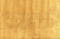
Map Pencil on paper with pencil overwrite Subdivisions in South half of Hiram H. Russell Survey ------------------------------------------------------------------ Hoskins Mound Territory ------------------------------------------------------------------ North arrow: no North direction: top of map, offset 27 degrees clockwise Compass bearings: no Scale: not shown; scales at 1" = 1000 feet Scale unit: feet Prominent features: - Austin Bayou - Hiram. H. Russell Survey - Block 16 - Block 17 - Block 18 - Block 19 Hoskins mound is not shown. |
Subjects |
Austin Bayou Hiram H. Russell Survey Hoskins Mound Map plat Russell Survey survey |
People |
Bass, Nan Russell, Hiram H. Hoskins |
Extent of Description |
Paper: 21" wide x 14.5" high Image: 16" wide x 8" high |
Collection |
Nan Bass |
Accession number |
1988.070c |
Other number |
1988-70-179 |
Source |
Nan Bass |
Credit line |
Nan Bass |
Lexicon category |
8: Communication Artifact |
Catalog type |
Map |
Condition |
Fair |
Imagefile |
007\1988.070c.0179.JPG |
Number of images |
1 |