
Archive Record
Images
Metadata
Object Name |
Map |
Catalog Number |
2008.010c.0018 |
Title |
Map - Mouth of the Brazos River |
Search Terms |
Brazos and Galveston Canal Brazos River Gulf of Mexico Gulf Intracoastal Waterway Jetties Old Velasco Quintana Surfside |
Scope & Content |
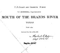
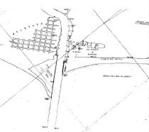
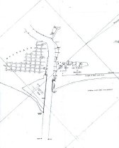
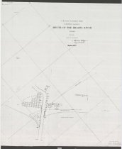
Map - Mouth of the Brazos River Reg No. 2047 Positive photostat ------------------- TRANSCRIPT OF TITLE BLOCK ----------------- U. S. Coast & Geodetic Survey T. C. Mendenhall, Superintendent MOUTH OF THE BRAZOS RIVER Texas Scale 1:10000 Surveyed Dec. 9t h. to 19t h, 1891 By /Herbert G. Ogden/ Asst. [illegible] Reg. No. 2047 -------------------------------------------------------------------------------------- North arrow: yes (Magnetic Meridian) Compass bearings: no Scale: 1:10,000 Scale unit: ratio Prominent features: - Brazos and Galveston Canal (now Intracoastal Waterway) - Brazos River (not labeled) - Gulf of Mexico - Jetties - Old Velasco or Surfside - Quintana (not to scale) |
People |
Mendenhall, T.C. Ogden, Herbert G. |
Date |
December 1891 |
Dates of Creation |
December 1891 |
Extent of Description |
Paper: 25" wide x 32" high Image: 25" wide x 30" high |
Collection |
U. S. Coast Survey - Coast of Texas |
Accession number |
2008.010c |
Source |
BCHM |
Credit line |
BCHM |
Lexicon category |
8: Communication Artifact |
Catalog date |
2012-09-11 |
Catalog type |
Archive |
Imagefile |
029\2008010c0018.JPG |
Number of images |
4 |