
Archive Record
Images
Metadata
Object Name |
Map |
Catalog Number |
1988.070c.0116 |
Title |
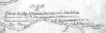
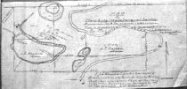
Map - Mary Scoby 775 acres survey in C.Smith Lg.Brazoria Co. Tex. & the original subdivisions. |
Search Terms |
Blueprint Cornelius Smith League Hudson Woods Map Oyster Creek Sally Lake Scoby Lake SH 35 State Highway 35 William. Roberts League |
Scope & Content |
Map Ink on linen for blue reproduction. -------------------------------------------------------------------------------------------- Map of Mary Scoby 775 acres survey in C.Smith Lg.Brazoria Co. Tex. & the original subdivisions. Made by Trimble, C.E. & re-surveyed 10-16-06 by Me. J. L. Chambers, Co. Suvr of B. C. Texas. -------------------------------------------------------------------------------------------- Land now located north of Bailey's Praire along both sides of SH 36. Includes land now located in Hudson Woods Unit of San Bernard National Wildlife Refuge. North arrow: yes North direction: toward top of map Compass bearings: no Scale: not shown Scale unit: vara Apparent scale: 300 feet/inch Prominent features: - Oyster Creek - Scoby Lake - Sally Lake - "Road" (now SH35) - South line of Wm Roberts League Property Owners: - Harden, J. T. - McMillan, T.J. & Vieman, L.D. |
Subjects |
Blueprint Cornelius Smith League Hudson Woods Map Oyster Creek Sally Lake Scoby Lake SH 35 State Highway 35 William. Roberts League |
People |
Bass, Nan Chambers, J. Lee Harden, J.T. McMillan, T.J. Roberts, William Scoby, Mary Smith, Cornelius Trimble Vieman, L.D. |
Date |
10/10/1906 |
Dates of Creation |
October 16, 1906 |
Extent of Description |
Paper: 15" wide x 7.5" high Image: 14.7" wide x 7.0" high |
Collection |
Nan Bass |
Accession number |
1988.070c |
Other number |
1988-70-116 |
Source |
Nan Bass |
Credit line |
Nan Bass |
Lexicon category |
8: Communication Artifact |
Catalog type |
Map |
Condition |
Fair |
Imagefile |
007\1988.070c.0116-1.JPG |
Number of images |
2 |