
Archive Record
Images
Metadata
Object Name |
Map |
Catalog Number |
2011.001c.0008 |
Title |
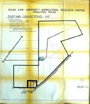
Map - Texas A&M Agricultural Station - Angleton - Existing Conditions |
Search Terms |
Agricultural Research Station #3 Agriculture AgriLife BCMGA BCPD BEES Brazoria County Agrilife Extension Service Brazoria County Cooperative Extension Service Brazoria County Master Gardeners Association Brazoria County Parks Department Brazoria Environmental Education Station CR171 Department of Agriculture Extension Service FM523 (not shown on map) M.P.R.R. Master Gardeners Association Missouri Pacific Railroad Old Danbury Road SH35 TAMU Texaco Texas A&M University Texas AgriLife Extension Service Texas Cooperative Extension Service Union Pacific Railroad USDA |
Scope & Content |
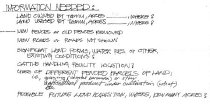
Map - Texas A&M Agricultural Station - Angleton - Existing Conditions Diazotype whiteprint with colored ink overwrite No date (before FM523 was constructed) ----------------- TRANSCRIPT OF TITLE BLOCK -------------------- Texas A&M University Agricultural Research Station Angleton, Texas Existing Conditions Map Information needed: - Land owned by TAMU, acres 156, where? - Land leased by TAMU, acres 405 Texaco 95 (illegible), where? - New fences or old fences removed - New roads or roads not shown - Significant land forms, water res, or other existing conditions? - Cattle handling facility location? - Uses of fenced parcels of land, i.e., grazing (coastal bermuda) or other agricultural product under cultivation (what), etc. - Possible future land acquisition, where, how many acres? --------------------------------------------------------------- North arrow: yes North arrow direction: top of map Compass bearings: no Scale: graphic (scales at 300'-1") Scale unit: foot Prominent Features: - Boundaries of TAMU property - Internal roads within property - Hospital Drive - Missouri Pacific Railway (now UPRR) - Old Danbury Road (now CR171) - Outlines of buildings - SH35 - Texas Communications Center (no longer extant) Not shown: FM523 right-of-way, which now crosses the property from north to south. See Notes & Legal. |
Dates of Creation |
Not shown on map. Before costruction FM523. |
Year Range from |
1980 |
Year Range to |
1990 |
Extent of Description |
Paper: 36" wide x 40" high Image: 33" wide x 37" high |
Collection |
County Clerk Elections Department |
Accession number |
2011.001c |
Source |
County Clerk Elections Department |
Lexicon category |
8: Communication Artifact |
Catalog date |
2012-01-24 |
Catalog type |
Archive |
Imagefile |
027\2011001c0008.JPG |
Number of images |
2 |