
Archive Record
Images
Metadata
Object Name |
Map |
Catalog Number |
2008.010c.0007 |
Title |
Map - Coast of Texas and Brazos River mouth |
Search Terms |
Brazos River Coast of Texas Gulf of Mexico Hydrography Point Bolivar Schooner Arago Shoreline U. S. Coast & Geodetic Survey |
Scope & Content |
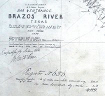
Map Coast of Texas and Brazos River mouth Part of U.S. Coast Survey Positive Photostat ------------------------------------------------------------------------------------------- U. S. Coast Survey A.D.Bache, Supt. Bar and Entrance Brazos River, Texas By the Hydrographic Party under the Command of Lieut. J. K. Duer, U.S.N. Asst. C.S. Scale 1/10000 1858 The Soundings are in feet Register No. 656 ------------------------------------------------------------------------------------------- North arrow: no North direction: parallel to meridians Compass bearings: no Scale: 1:10,000 Scale unit: ratio |
Subjects |
Brazos River Coast of Texas Gulf of Mexico Hydrography Point Bolivar Schooner Arago Shoreline U. S. Coast & Geodetic Survey |
People |
Bache, A.D. DeHaven, Edwin J. Duer, J.K. |
Date |
1858 |
Dates of Creation |
1858 |
Year Range from |
1858 |
Year Range to |
1858 |
Extent of Description |
Paper: 54" wide x 35" high Image: 52" wide x 31" high |
Collection |
U. S. Coast & Geodetic Survey of Texas Coast |
Accession number |
2008.010c |
Source |
BCHM |
Credit line |
BCHM |
Lexicon category |
8: Communication Artifact |
Catalog date |
2008-04-08 |
Catalog type |
Archive |
Imagefile |
021\2008.010c.0007-1.jpg |
Number of images |
1 |