
Archive Record
Images
Metadata
Object Name |
Map |
Catalog Number |
2009.013c.0008 |
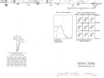
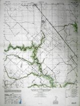
Title |
Map - 1947 USGS 7.5-minute map Genoa (now Friendswood), Texas quadrangle |
Search Terms |
Chigger Creek Clear Creek Clover (Oil Field Cowart Creek FM 2351 FM 518 Friendswood quadrangle Galveston County (partial Galveston Houston and Henderson Railroad Genoa Genoa Quadrangle Harris County Hastings Hastings Oil Field Map Marys Creek Pearland Pearland Friendswood Road SH 35 Turkey Creek USGS 7.5-minute map West Friendswood Road |
Scope & Content |
Map 1947 USGS 7.5-minute map Genoa (now Friendswood), Texas quadrangle North arrow: yes North direction: top of map Compass bearings: no Scale: 1:24,000 Civil: - Clover (Oil) Field - Galveston County (partial) - Genoa - Harris County (partial) - Hastings - Hastings Oil Field - Pearland Major waterways: - Chigger Creek - Clear Creek - Cowart Creek - Marys Creek - Turkey Creek Major transportation infrastructure: - Galveston Houston and Henderson Railroad (no longer extant) - Pearland Friendswood Road (now FM 518) - SH 35 - West Friendswood Road (now FM 2351) |
Subjects |
Chigger Creek Clear Creek Clover (Oil Field Cowart Creek FM 2351 FM 518 Friendswood quadrangle Galveston County (partial Galveston Houston and Henderson Railroad Genoa Genoa Quadrangle Harris County Hastings Hastings Oil Field Map Marys Creek Pearland Pearland Friendswood Road SH 35 Turkey Creek USGS 7.5-minute map West Friendswood Road |
Date |
1947 |
Dates of Creation |
1947 |
Year Range from |
1943 |
Year Range to |
1947 |
Extent of Description |
22" wide x 29" high |
Collection |
Transfer from Library Collection |
Accession number |
2009.013c |
Old ID number |
96.71.01 |
Source |
Transfer from Library Collection |
Lexicon category |
8: Communication Artifact |
Catalog date |
2009-09-29 |
Catalog type |
Archive |
Imagefile |
023\2009.013c.0008-1.jpg |
Number of images |
4 |