
Archive Record
Images
Metadata
Object Name |
Map |
Catalog Number |
2014.011c.0003 |
Title |
Map with explanatory pamphlet and sleeve Geologic Atlas of Texas, Beevillle-Bay City Sheet Alexander Deussen Memorial Edition |
Search Terms |
Aransas Bay Aransas National Wildlife Refuge Bay City (city) Beeville (city) Bureau of Economic Geology Colorado River Copano Bay East Matagorda Bay Espiritu Bay Fulton (city) Garcitas River Geologic Atlas of Texas Geologic Atlas of Texas Goliad (city) Guadalupe River Lake Corpus Christi Lake Texana Lavaca Bay Map Matagorda Bay Matagorda Island Matagorda Island State Park and Wildlife Management Area Mission Bay Mission River Navidad River Palacios (city) Port Lavaca (city) Refugio (city) Rockport (city) San Antonio Bay San Antonio River South Texas Nuclear Project Reservoir St. Joseph Island University of Texas at Austin] Victoria (city) |
Scope & Content |
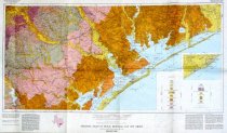
Map with explanatory pamphlet and sleeve Geologic Atlas of Texas, Beevillle-Bay City Sheet Alexander Deussen Memorial Edition Revised 1987 ---------- Items in this Object ID ------------ 2014.011c.0003(a) Map - Lithograph in color on paper Further description below ----------------------------------------------- 2014.011c.0003(b) Brochure - printed black ink on paper ----------------------------------------------- 2014.011c.0003(c) Sleeve containing (a) and (b). ----------------------------------------------- ========================================= FURTHER DESCRIPTION OF 2014.011c.0003(a) Map Map - Lithograph in color on paper North arrow: no North direction: top of map Scale: 1:250,000 Scale Unit: Statute miles, kilometers, and nautical miles Transverse Mercator Projection Boundaries: - East: 95 deg 35 min approx - South: 28 deg 00 min - West: 98 deg 00 min - North 29 deg 00 min ========================================= |
People |
Fisher, W.L. (Director, Bureau of Economic Geology, University of Texas at Austin) Barnes, Virgil E (Project Director) |
Date |
1987 |
Dates of Creation |
1975 revised 1987 |
Year Range from |
1975 |
Year Range to |
1987 |
Extent of Description |
2014.011c.0003(a) Map - Lithograph in color on paper 39" wide x 23" high ----------------------------------------------- 2014.011c.0003(b) Brochure - printed black ink on paper 8 pages including covers 8.5" wide x 11" high ----------------------------------------------- 2014.011c.0003(c) Sleeve - colored paper 9" wide x 12" high |
Collection |
David S. Pettus |
Accession number |
2014.011c |
Source |
David S. Pettus |
Lexicon category |
8: Communication Artifact |
Catalog date |
2014-03-11 |
Catalog type |
Archive |
Imagefile |
035\2014011c0003-2.JPG |
Number of images |
2 |