
Archive Record
Images
Metadata
Object Name |
Map |
Catalog Number |
2008.010c.0004 |
Title |
Map - Coast of Texas and Brazos River mouth |
Search Terms |
Brazos River Coast of Texas Gulf of Mexico Hydrography Point Bolivar Shoreline U. S. Coast & Geodetic Survey |
Scope & Content |
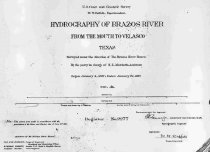
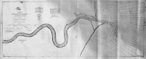
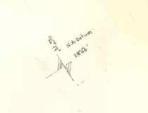
Map Coast of Texas and Brazos River mouth Part of U.S. Coast Survey Positive Photostat ------------------------------------------------------------------------------------------- U. S. Coast and Geodetic Survey W. W. Duffield, Superintendent Hydrography of Brazos River From the Mouth to Velasco Texas Surveyed under the direction of The Brazos River Board By the party in charge of H. L. Marindin, Assistant Begun January 4, 1897; Ended January 27, 1897 Scale: 1/50000 Register No. 2277 ------------------------------------------------------------------------------------------- North arrow: no North direction: parallel to meridian 95 deg 19 min Compass bearings: no Scale: 1:50,000 Scale unit: ratio |
Subjects |
Brazos River Coast of Texas Gulf of Mexico Hydrography Point Bolivar Shoreline U. S. Coast & Geodetic Survey |
People |
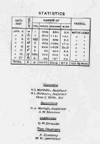
DeHaven, Edwin J. Lawrence, W.W. Marindin, H.L. Shannon, A.W. Moore, Robert Robert, Henry M. Forney, Stehman Coveney, A. Baldwin, A.L. Yates, Charles C. |
Date |
01/27/1897 |
Dates of Creation |
01/27/1897 |
Year Range from |
1897 |
Year Range to |
1897 |
Extent of Description |
Paper: 79" wide x 34" high |
Collection |
U. S. Coast & Geodetic Survey of Texas Coast |
Accession number |
2008.010c |
Source |
BCHM |
Credit line |
BCHM |
Lexicon category |
8: Communication Artifact |
Catalog date |
2008-04-04 |
Catalog type |
Archive |
Imagefile |
021\2008.010c.0006-1.jpg |
Number of images |
5 |