
Archive Record
Images
Metadata
Object Name |
Map |
Catalog Number |
1988.070c.0097 |
Title |
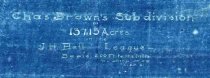
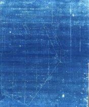
Map - Charles Brown subdivision in Joshua Bell league |
Search Terms |
Joshua.H. Bell League Blueprint map Charles Brown Subdivision plat survey T. L. Smith Civil Engineer |
Scope & Content |
Map Cyanotype Blueprint Charles Brown Subdivision --------------------------------------------------------------------------------------------- Chas Brown's Sub Division of 137.15 acres in the Joshua. H. Bell League Scale 200 ft to the inch. T. L. Smith, Jr. Civil Engineer. 6-25-01 --------------------------------------------------------------------------------------------- North arrow: yes North direction: top of map Compass bearings: no Scale: 1" = 200 feet Scale unit: feet Property owners: - Arnold - Bartlett, J. S. - McGill & Hensely - Smith, T. L., Jr. - Wilson, L. J. |
Subjects |
Joshua.H. Bell League Blueprint map Charles Brown Subdivision plat survey T. L. Smith Civil Engineer |
People |
Arnold Bartlett, J.S. Bass, Nan Bell, Josiah Hughes Brown, Charles Hensely McGill Smith, T.L. Jr. Wilson, Louis J. |
Dates of Creation |
6/25/1901 |
Extent of Description |
Paper: 16" wide x 19" high Image: 14.5" wide x 19" high |
Collection |
Nan Bass |
Accession number |
1988.070c |
Other number |
1988-70-97 |
Source |
Nan Bass |
Credit line |
Nan Bass |
Lexicon category |
8: Communication Artifact |
Catalog type |
Map |
Condition |
Fair |
Imagefile |
007\1988.070c.0097-1.JPG |
Number of images |
2 |