
Archive Record
Images

Metadata
Object Name |
Map |
Catalog Number |
2008.034c.0004 |
Title |
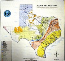
Map - Major Texas Rivers (Texas Water Development Board) |
Search Terms |
Allens Creek Reservoir Brazoria County Brazoria Reservoir Brazos River Canadian River Carrizo-Wilcox Aquifer Cedar Lake Creek Cenezoic Pecos Alluvium Aquifer Colorado River Cypress Creek Eagle Nest Lake Edwards Aquifer Edwards-Trinity Plateau Aquifer Gulf Coast Aquifer Hueco-Misilla Bolson Aquifer Manor Lake Medina River Mustang Lake Neches River Nueces River Ogallala Aquifer Prairie Dog Fork of Red River Red River Reservoirs Rio Grande River Sabine river San Bernard Reservoir San Bernard River San Jacinto River Seymour Aquifer Sulphur River Texas Boundaries Texas Water Development Board Trinity Aquifer Trinity River Water Resources William Harris Reservoir |
Scope & Content |
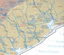
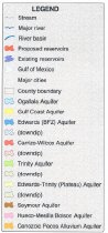
Map Printed on paper in color ---------------------------------------------------------------------------------------------- Texas Water Development Board Major Texas Rivers Including Existing Reservoirs, River Basins, Streams, and Major Aquifers whose colors have been purposely subdued. April 2002 Prepared by Mark Hayes Mapping Coordinator, TWDB mark.hayes@twdb.state.tx.us 512-936-0828 ---------------------------------------------------------------------------------------------- North arrow: yes (compass rose) North direction: top of map Compass bearings: no Scale: graphic; approximately 1" = 25 miles Scale unit: miles Prominent Features: - Brazos River - Canadian River - Carrizo-Wilcox Aquifer - Cedar Lake Creek (as county boundary line) - Cenezoic Pecos Alluvium Aquifer - Colorado River - Counties - County boundaries - Cypress Creek - Edwards Aquifer - Edwards-Trinity Plateau Aquifer - Gulf Coast - Gulf Coast Aquifer - Hueco-Misilla Bolson Aquifer - Medina River - Neches River - Nueces River - Ogallala Aquifer - Prairie Dog Fork of Red River - Red River - Reservoirs - Rio Grande River - Sabine river - San Bernard River (as light blue dashed line) - San Jacinto River - Seymour Aquifer - Sulphur River - Texas Boundaries - Trinity Aquifer - Trinity River |
Subjects |
Allens Creek Reservoir Brazoria County Brazoria Reservoir Brazos River Canadian River Carrizo-Wilcox Aquifer Cedar Lake Creek Cenezoic Pecos Alluvium Aquifer Colorado River Cypress Creek Eagle Nest Lake Edwards Aquifer Edwards-Trinity Plateau Aquifer Gulf Coast Aquifer Hueco-Misilla Bolson Aquifer Manor Lake Medina River Mustang Lake Neches River Nueces River Ogallala Aquifer Prairie Dog Fork of Red River Red River Reservoirs Rio Grande River Sabine river San Bernard Reservoir San Bernard River San Jacinto River Seymour Aquifer Sulphur River Texas Boundaries Texas Water Development Board Trinity Aquifer Trinity River Water Resources William Harris Reservoir |
People |
Hayes, Mark |
Date |
Afpril 2002 |
Dates of Creation |
April 2002 |
Year Range from |
2002 |
Year Range to |
2002 |
Extent of Description |
Paper: 35" wide x 35" high Image: 34" wide x 34" high |
Collection |
BCHM |
Accession number |
2008.034c. |
Source |
Museum purchase |
Lexicon category |
8: Communication Artifact |
Catalog date |
2008-10-03 |
Catalog type |
Archive |
Imagefile |
022\2008.034c.0004-1.JPG |
Number of images |
4 |