
Archive Record
Images
Metadata
Object Name |
Map |
Catalog Number |
2009.024c.0001 |
Title |
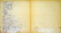
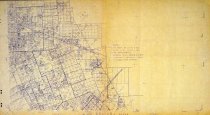
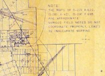
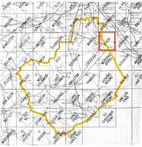
Map - Algoa USGS quadrangle - Title Services Inc. Plat Map |
Search Terms |
Algoa Alvin (City) Alvin Bypass (SH36) Alvin Junction (UPRR) BNSF Railway Bolson & Nelson CR 133 CR 154 CR 155 CR 156 CR 157 CR 158 CR 160 CR 161 CR 166 CR 414 CR 414 FM 2462 FM 517 FM 528 Gulf, Colorado and Santa Fe Railway Hooper & Wade Houston Tap and Brazoria Railway LOOP 409 Masterson Morgan, Alvin Mustang BayouQC Plat Map SH 35 SH 6 South Texas Development Co. Title Services Inc. USGS quadrangle map Buffalo Bayou, Brazos and Colorado Railway International & Great Northern Railroad |
Scope & Content |
Map Title Services Inc. Plat Map Algoa USGS quadrangle Diazotype Whiteprint in two sheets designated 2009.024c.0001-N 2009.024c.0001-S North arrow: no North direction: top of map Compass bearings: no Scale: 1:12,000 ABSTRACTS - see NOTES CIVIL: - Alvin (city) ORIGINAL GRANTEES: - BBB&C Railway - Bolson & Nelson - Buffalo Bayou, Brazos and Colorado Railway Company - Dungaugh, L.C. - Harris, W.M. - Hennell - Hooper & Wade - Houston Tap & Brazoria Railway - HT&B - Hughes, W.T. - I&GN - International-Great Northern Railroad - Magee, Richard - Masterson, B.T. - Morgan, Alvin - O'Donnell, Myles - O'Donnell, M.V. - Skeet, H. L. - South Texas Development Co. - Stevens - Weir, R.L. TRANSPORTATION INFRASTRUCTURE: - Alvin Bypass - Alvin Junction - CR 133 - CR 154 - CR 155 - CR 156 - CR 157 - CR 158 - CR 160 - CR 161 - CR 166 - CR 414 - CR 414 - FM 2462 - FM 517 - FM 528 (Friendswood Road) - GC&SF Railroad - Gulf, Colorado, and Santa Fe Railroad (now BNSF) - LOOP 409 - SH 35 - SH 6 WATERWAYS: - Chigger Creek (not labeled) - Mustang Bayou (not labeled) |
Subjects |
Algoa Alvin (City) Alvin Bypass (SH36) Alvin Junction (UPRR) BBB&C BNSF Railway Bolson & Nelson Buffalo Bayou, Brazos and Colorado Railway CR 133 CR 154 CR 155 CR 156 CR 157 CR 158 CR 160 CR 161 CR 166 CR 414 CR 414 FM 2462 FM 517 FM 528 GC&SF Railroad Gulf, Colorado, and Santa Fe Railroad Hooper & Wade Houston Tap & Brazoria Railway HT&B I&GN International-Great Northern Railroad LOOP 409 Masterson Morgan, Alvin Mustang BayouQC Plat Map SH 35 SH 6 South Texas Development Co. Title Services Inc. USGS quadrangle map |
People |
Dunbaugh, L.C. Harris, W.M. Hughes, W.T. Magee, Richard A. Masterson, Branch T. Morgan, Alvin O'Donnell, Mary V. O'Donnell, Myles Skeete, H.L. Tyson, Dick Weir, R.L. |
Date |
October 1979 |
Dates of Creation |
October 1979 |
Year Range from |
1979 |
Year Range to |
1979 |
Extent of Description |
Paper: 44" wide x 24" high Image: 42" wide x 24" high |
Collection |
White Collection |
Accession number |
2009.024c |
Old ID number |
6B |
Other number |
Algoa Quadrangle |
Source |
Dick Tyson |
Credit line |
Dick Tyson |
Lexicon category |
8: Communication Artifact |
Catalog date |
2009-08-18 |
Catalog type |
Archive |
Imagefile |
023\2009.024c.0001-N.jpg |
Number of images |
4 |
Received date |
Aug. 2008 |