
Archive Record
Images
Metadata
Object Name |
Map |
Catalog Number |
1988.070c.0028 |
Title |
Map - Port Brazos |
Search Terms |
Blueprint map Port Brazos, Texas plat survey |
Scope & Content |
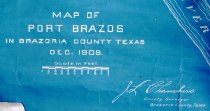
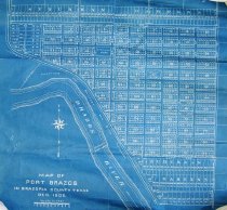
Map Cyanotype Blueprint ----------------------------------------------------------------------------------------- Port Brazos, Brazoria County, Texas, Dec 1909, J. L. Chambers, County Surveyor, Brazoria County, Texas ----------------------------------------------------------------------------------------- Lands now located within City of Lake Jackson between east bank of Brazos River and present-day Canna Lane. North arrow: yes North direction: top of map Compass bearings: yes Scale: 1" = 300 feet Scale unit: feet Prominent features: - Brazos River (identified as being 22 feet deep and 600 feet wide) - 100-foot ROW reserved for railroad (apparently never built) - E-W Streets named after U. S. Presidents - N-S Streets named 1st St. to 11th St. - City block designated "City Hall Park" - City block designated "City Plaza" - Outlot between river and railroad designated "reserved for railroad and dock purposes" |
Subjects |
Blueprint map Port Brazos, Texas plat survey |
People |
Bass, Nan |
Date |
1901 |
Dates of Creation |
Start date - 1909, Enddate - 1909 |
Extent of Description |
Paper: 23" wide x 28" high Image: 22" wide x 27" high |
Collection |
Nan Bass |
Accession number |
1988.070c |
Other number |
1988-70-28 |
Source |
Nan Bass |
Credit line |
Nan Bass |
Lexicon category |
8: Communication Artifact |
Catalog date |
1909-01-01 |
Catalog type |
Map |
Condition |
Fair |
Imagefile |
007\1988.070c.0028-1.jpg |
Number of images |
3 |