
Archive Record
Images
Metadata
Object Name |
Map |
Catalog Number |
1988.070c.0167 |
Title |
Map - G. M. Henderson subdivision of Valderas |
Search Terms |
Angleton Brushy Bayou CR 341 CR 48 Harvest Glen Henderson Road Henderson Subdivision North Valderas Street Remington Street Valderas Survey |
Scope & Content |
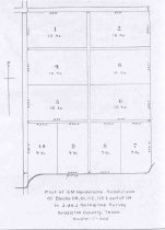
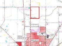
Map Ink on finely woven cloth -------------------------------------------------------------------------------------- Plat of G. M. Henderson's subdivision Of Blocks 110, 111, 112, 113, and part of 114 In Jose de Jesus Valderas Survey Brazoria County, Texas Scale 1" = 300' -------------------------------------------------------------------------------------- North arrow: yes North direction: top of map Compass bearings: no Scale: 1" = 300 feet Scale unit: feet Prominent Features: - Ditch (now Brushy Bayou) - Platted lots numbered 1-10 - Roadway ROW 60' (now Henderson Street/CR 341). - Roadway ROW 60' (now North Valderas Street/CR 48). |
Subjects |
Angleton Brushy Bayou CR 341 CR 48 Harvest Glen Henderson Road Henderson Subdivision North Valderas Street Remington Street Valderas Survey |
People |
Bass, Nan Henderson, G.M. Valderas, Jose de Jesus |
Extent of Description |
Paper: 8.5" wide x 11.5" high Image: 8" wide x 11" high |
Collection |
Nan Bass |
Accession number |
1988.070c |
Other number |
1988-70-167 |
Source |
Nan Bass |
Credit line |
Nan Bass |
Lexicon category |
8: Communication Artifact |
Catalog type |
Map |
Condition |
Fair |
Imagefile |
007\1988.070c.0167.jpg |
Number of images |
2 |