
Archive Record
Images
Metadata
Object Name |
Map |
Catalog Number |
1988.070c.0041 |
Title |
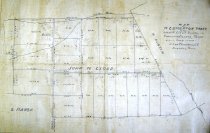
Map - W. C. Stockton Tract in the John W. Cloud Survey |
Search Terms |
Survey map Map of W. C. Stockton tract John W.Cloud Survey Brazoria County, Texas plat survey Brushy Bayou Flores Bayou |
Scope & Content |
Survey map Ink on finely woven cloth with pencil overwrite -------------------------------------------------------------------------------------------- Map of W. C. Stockton Tract in the John W. Cloud Survey in Brazoria County, Texas. 8-5-11, Scale 1" = 1000" (sic). J. Lee Chambers, Civil Engineer, Angleton, Texas. -------------------------------------------------------------------------------------------- North arrow: no North direction: top of map (?) Compass bearings: yes Scale: 1 inch = 1000 feet Scale unit: feet Prominent features: - Flores Bayou - Brushy Bayou - John W. Cloud Survey - H. Austin Survey - Roadway ROWs - Notation on road: "Angleton 3 Miles" with arrow pointing south |
Subjects |
Survey map Map of W. C. Stockton tract John W.Cloud Survey Brazoria County, Texas plat survey Brushy Bayou Flores Bayou |
People |
Stockton, W.C. Cloud, John Wirtz Bass, Nan Marsh, Shubal Austin, H. |
Date |
1911 |
Dates of Creation |
1911 |
Year Range from |
1911 |
Year Range to |
1911 |
Extent of Description |
Paper: 19.7" wide x 13.5" high Image: 18.1" wide x 11.8" high |
Collection |
.Nan Bass |
Accession number |
1988.070c |
Other number |
1988-70-41 |
Source |
Nan Bass |
Credit line |
Nan Bass |
Lexicon category |
8: Communication Artifact |
Catalog date |
1911-01-01 |
Catalog type |
Map |
Condition |
Fair |
Imagefile |
007\1988.070c.0041.jpg |
Number of images |
1 |