
Archive Record
Images
Metadata
Object Name |
Map |
Catalog Number |
1988.070c.0231 |
Title |
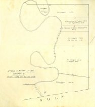
Map - Branch T. Archer league - Abstract 9 |
Search Terms |
Abstract #009 Archer, Branch Tanner Gulf of Mexico Gulf Intracoastal Waterway Oyster Creek United States Government property Coast Guard |
Scope & Content |
Map Red and black ink on translucent drafting paper -------------------------------------------------------------------------- Branch T. Archer league Abstract 9 Scale 500 vrs to an inch -------------------------------------------------------------------------- North arrow: yes North direction: top of map clockwise about 30 degrees Compass bearings: no Scale: 1" = 500 varas Scale unit: vara Prominent features: - Canal (Galveston-Brazos Canal) - Gulf of Mexico - Mouth of Oyster Creek at Gulf (no longer extant) - Oyster Creek (before construction of Intracoastal Waterway) -USCG (Freeport Coast Guard Station/Life Saving Station) Landowners and leaseholders: - Cannon, E.B. - Cannon, E.B. Estate - Catherwood, J.H. - Davidson, J.L. - Dorchester, E.D. - Hudgins, J.L. - Hudgins, S. - Hudgins, S.H. - Lazarus, Sam - Masterson & Lacharie - Taylor, H.D. and sons - United States Government - Wheeless, J.S. |
Subjects |
Branch T. Archer league Gulf of Mexico Intracoastal Waterway Oyster Creek United States Government property USCG ( Coast Guard Station location) |
People |
Archer, Branch Tanner Bass, Nan Cannan, E.B. Catherwood, J.H. Davidson, J.L. Dorchester, E.D. Hudgins, John Longest Hudgins, Sam Houston Lazarus, Sam Taylor, H.D. Wheeless, J.S. |
Extent of Description |
Paper: 24" wide x 18" high Image: 28" wide x 17" high |
Collection |
Nan Bass |
Accession number |
1988.070c |
Other number |
1988-70-231 |
Source |
Nan Bass |
Credit line |
Nan Bass |
Lexicon category |
8: Communication Artifact |
Catalog type |
Map |
Condition |
Fair |
Imagefile |
067\1988070c0231.JPG |
Number of images |
1 |