
Archive Record
Images
Metadata
Object Name |
Map |
Catalog Number |
2013.003c.0012 |
Title |
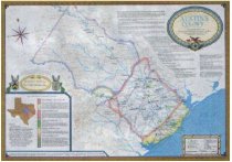
Map - Austin's Colony 1821-1836 (reproduction 1993) |
Search Terms |
Austin's Coast Colony Austin's Colony Austin's Colony 1821 - 1936 Austin's Little Colony Austin's Upper Colony Bastrop Bell's Landing Bolivar Brazoria Clopper's Point Columbia Columbus East Columbia Egypt Fort Bend Fort Settlement Garry Mauro - Commissioner Harrisburg Independence Lower Settlement Lynch's Ferry Lynchburg Marion Matagorda Mercer's Ferry Milam Mina Montezuma Morgan's Point New Washington Orozimbo Peach Point Plantation Phelps' Plantation Richmond Rightor's Point Robinson's Ferry San Felipe Santa Anna Sarahville de Viesca Season's Crossing Stafford Stafford's Point Stafford's Prairie Stephen F. Austin Texana Texas General Land office University of Texas Printing Velasco Washington-on-the-Brazos West Columbia |
Scope & Content |
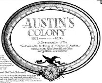
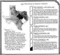
Map - Austin's Colony 1821 - 1836 (published 1993) © 1993 Texas General Land Office Printed by University of Texas Printing Color lithograph --------------------------------------------------------------------------------------------- TRANSCRIPT OF TITLE BLOCK and ACCOMPANYING NOTES Austin's Colony 1821 - 1936 In Commemoration of the The-Hundredth Birthday of Stephen F. Austin Published by the Texas General Land office Garry Mauro - Commissioner Notes on Original Towns and Settlements as they existed in 1835 - Season's Crossing (Montezuma, Columbus) - Bell's Landing (Marion, East Columbia) - Bolivar - Brazoria - Columbia (West Columbia) - Fort Settlement (Lower Settlement, Fort Bend, Richmond) - Harrisburg - Independence - Lynch's Ferry (Lynchburg) - Matagorda - Mina (Bastrop) - Mercer's Ferry (Egypt) - Milam (Sarahville de Viesca) - New Washington (Rightor's Point, Clopper's Point, Morgan's Point) - Orozimbo (Phelps' Plantation) - Peach Point Plantation - Robinson's Ferry (Washington on the Brazos) - San Felipe - Santa Anna (Texana) - Stafford's Point (Stafford's Prairie, Stafford) - Velasco Key to Boundaries of Austin's Contracts - First Contract, 1821 (300 families; ratified 1823) - Second Contract, 1825 (500 families) - Third Contract, 1827 (100 families; "Little Colony") - Fourth Contact, 1828 (300 families; "Coast Colony") - Fifth Contract, 1831 (800 families; "Upper Colony") |
People |
Austin, Stephen Fuller Mauro, Garry |
Date |
1993 |
Dates of Creation |
Date of map contents: 1821-1836 Date of production of this map: 1993 200th anniversary of birth of SFA |
Extent of Description |
35" wide x 25" high |
Collection |
Transfer from Library Files |
Accession number |
2013.003c |
Other number |
Austin's Colony 1821-1936 |
Source |
Transfer from Library Files |
Credit line |
Found in Collection |
Lexicon category |
8: Communication Artifact |
Catalog date |
2013-04-02 |
Catalog type |
Archive |
Imagefile |
030\2013003c0012.JPG |
Number of images |
4 |
Classification |
Garry Mauro, Commissioner, Texas General Land Office |
Received date |
01/14/2013 |