
Archive Record
Images

Metadata
Object Name |
Map |
Catalog Number |
2008.010c.0019 |
Title |
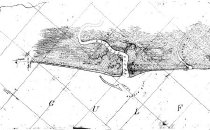
Map - U. S. Coast Survey - Texas Coast - Jupiter to St. Luis pass |
Search Terms |
Bastrop Bay Brazos River Christmas Bay Drum Bay Gulf of Mexico Gulf Intracoastal Waterway Jupiter New Canal Oyster Creek Rattlesnake Point St Luis Texas Coast U. S. Coast Survey |
Scope & Content |
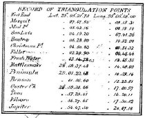
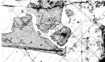
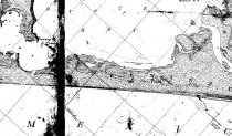
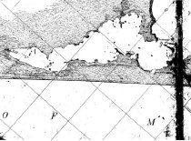
Map - U. S. Coast Survey Texas Coast - Jupiter to St. Luis pass Reg No. 2047 Positive photostat ----- TRANSCRIPT OF TITLE BLOCK ------------------------------ Map of Texas Coast From St Luis to Jupiter U.S. Coast Survey A.D. Bache, Supt. Sheet No.______ Topog'l survey map made by J.M. Wampler, Sub Assist't In February and March 1852 Scale: 1:20000 ----------------------------------------------------------------------------- North arrow: no Latitude/Longitude: yes Compass bearings: no Scale: 1:20000 Scale unit: ratio Prominent features: - Bastrop Bay (not labeled) - Brazos River - Christmas Bay (not labeled) - Drum Bay (not labeled) - Gulf of Mexico - Intracoastal Waterway (labeled "New Canal") - Jupiter - Oyster Creek - Rattlesnake Point |
Subjects |
Bastrop Bay Brazos River Christmas Bay Drum Bay Gulf of Mexico Intracoastal Waterway Jupiter New Canal Oyster Creek Rattlesnake Point St Luis Texas Coast U. S. Coast Survey |
People |
Bache, A.D. Wampler, J.M. |
Date |
1852 |
Dates of Creation |
1852 |
Extent of Description |
Pager: 75" wide x 30" high Image: 75" wide x 30" high" |
Collection |
U. S. Coast Survey - Coast of Texas |
Accession number |
2008.010c |
Source |
BCHM |
Credit line |
BCHM |
Lexicon category |
8: Communication Artifact |
Catalog date |
2012-09-18 |
Catalog type |
Archive |
Imagefile |
029\2008010c0019.JPG |
Number of images |
6 |