
Archive Record
Images
Metadata
Object Name |
Map |
Catalog Number |
1988.070c.0054 |
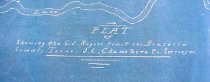
Title |
Map - C.J. Rogers tract in Brazoria County, Texas. |
Search Terms |
Blueprint Brazoria County, Texas C.J. Rogers tract Cedar Lake Bayou Cedar Lake Creek Cow Trap Lake Gulf of Mexico Houston Tap and Brazoria Railway Map plat survey |
Scope & Content |
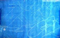
Map Cyanotype Blueprint C.J. Rogers Tract -------------------------------------------------------------------------------------------- Plat of showing the C.J. Rogers tract in Brazoria County, Texas. J. L. Chambers, co. Surveyor. -------------------------------------------------------------------------------------------- All land shown on this map is now located within the San Bernard National Wildlife Refuge. North arrow: yes North direction: top of map Compass bearings: yes Scale not shown; apparent scale is 1" = 1000 feet Scale unit: feet and varas Prominent features: - Cedar Lake - Cedar Lake Bayou (now Cedar Lake Creek) - Cow Trap Lake - Gulf of Mexico Property Owners: - Atsberry, G.G. and H.H. - Blundett, S. - Harding, William - Houston Tap and Brazoria Railroad - Mings, Martha - Rogers, C. J. - Summeratt, C. |
Subjects |
Blueprint Brazoria County, Texas C.J. Rogers tract Cedar Lake Cedar Lake Bayou Cedar Lake Creek Cow Trap Lake Gulf of Mexico Houston Tap and Brazoria Railroad Map plat survey |
People |
Chambers, J. Lee Atsberry, G.G. Atsberry, H.H. Blundell, S. Harding, William Mings, Martha Rogers, C.J. Summeratt, C. |
Extent of Description |
Paper: 28.3" wide x 17" high Image: 28.3" wide x 16.5" high |
Collection |
Nan Bass |
Accession number |
1988.070c |
Other number |
1988-70-54 |
Source |
Nan Bass |
Credit line |
Nan Bass |
Lexicon category |
8: Communication Artifact |
Catalog type |
Map |
Condition |
Fair |
Imagefile |
007\1988.070c.0054-1.JPG |
Number of images |
2 |