
Archive Record
Images

Metadata
Object Name |
Map |
Catalog Number |
2009.026c.0022 |
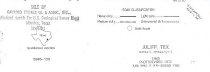
Title |
Map - 1974 USGS 7.5-minute map Juliff, Texas quadrangle |
Search Terms |
Arcola Arcola Junction Arcola Oil Field ATSF BNSF Railroad Bonner Slough Briscoe Canal Brown Lake Brushy Lake Chocolate Bayou Chocolate Bayou Water Co. Canal Chocolate Bayou West Fork Clear Lake CR 48 CR 48 CR 54 CR 56 CR 60 CR 65 CR 81 Darrington Unit FM 521 Fort Bend County Hawdon Hayes Creek Iowa Colony Iowa School Road Jackson Lake (not to be confused with Lake Jackson) Juliff Juliff Quadrangle Lake Sienna Lawson Lake Miller Lakes Missouri Pacific Railroad Mowrey Lake Mt. Tabor Church Old Airline Road Old Colony School Road Oyster Creek Pleasant Grove Cemetery Prison Cemetery Rawlings Lakes Sandy Point Sandy Point Cemetery Sandy Point Oil Field Santa Fe Railway SH 288 SH 288 SH 6 South Texas Water Company Canal St. Phillip Church Sugarhouse Lake Sugarland Railway Thompson Lake USGS 7.5-minute map Willow Lake |
Scope & Content |
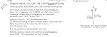
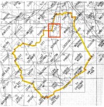
Map 1974 USGS 7.5-minute map Juliff, Texas quadrangle North arrow: yes North direction: top of map Compass bearings: no Scale: 1:24,000 Civil: - Arcola - Arcola Junction (not labeled) - Arcola Oil Field - Darrington Unit - Fort Bend County (Partial) - Hawdon - Iowa Colony - Juliff - Mt. Tabor Church - Pleasant Grove Cemetery - Prison Cemetery - Sandy Point - Sandy Point Cemetery - Sandy Point Oil Field - St. Phillip Church Major waterways: - Bonner Slough - Briscoe Canal - Brown Lake - Brushy Lake - Chocolate Bayou - Chocolate Bayou West Fork - Clear Lake - Hayes Creek - Jackson Lake (not to be confused with Lake Jackson) - Lake Sienna - Lawson Lake - Miller Lakes - Mowrey Lake - Oyster Creek - Rawlings Lakes - South Texas Water Company Canal (now Chocolate Bayou Water Co. Canal) - Sugarhouse Lake - Thompson Lake - Willow Lake Major transportation infrastructure: - CR 48 (not labeled) - CR 54 (not labeled) - CR 56 (not labeled) - CR 81 (not labeled) - Iowa School Road (now CR65) - Missouri Pacific Railway (no longer extant) - Old Airline Road (now CR48) - Old Colony School Road (now CR60) - Santa Fe Railway (now BNSF) - SH 288 (now FM 521) - SH 288 (present alignment, under construction) - SH 6 |
Subjects |
Arcola Arcola Junction Arcola Oil Field ATSF BNSF Railroad Bonner Slough Briscoe Canal Brown Lake Brushy Lake Chocolate Bayou Chocolate Bayou Water Co. Canal Chocolate Bayou West Fork Clear Lake CR 48 CR 48 CR 54 CR 56 CR 60 CR 65 CR 81 Darrington Unit FM 521 Fort Bend County Hawdon Hayes Creek Iowa Colony Iowa School Road Jackson Lake (not to be confused with Lake Jackson) Juliff Juliff Quadrangle Lake Sienna Lawson Lake Miller Lakes Missouri Pacific Railway Mowrey Lake Mt. Tabor Church Old Airline Road Old Colony School Road Oyster Creek Pleasant Grove Cemetery Prison Cemetery Rawlings Lakes Sandy Point Sandy Point Cemetery Sandy Point Oil Field Santa Fe Railway SH 288 SH 288 SH 6 South Texas Water Company Canal St. Phillip Church Sugarhouse Lake Sugarland Railway Thompson Lake USGS 7.5-minute map Willow Lake |
Date |
1974 |
Dates of Creation |
1963; photorevised 1974 |
Year Range from |
1963 |
Year Range to |
1974 |
Extent of Description |
23" wide x 27" high |
Collection |
Transfer from Library Collection |
Accession number |
2009.026c |
Old ID number |
206.01.01 |
Source |
Transfer from Library Collection |
Lexicon category |
8: Communication Artifact |
Catalog date |
2009-09-04 |
Catalog type |
Archive |
Imagefile |
023\2009.026c.0022-1.jpg |
Number of images |
4 |