
Archive Record
Images
Metadata
Object Name |
Map |
Catalog Number |
2009.013c.0001 |
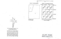
Title |
Map - 1980 USGS 7.5-minute map - Juliff, Texas quadrangle |
Search Terms |
Airline Road BNSF Railroad Bonner Slough Briscoe Canal Brushy Lake Chocolate Bayou Chocolate Bayou West Fork Clear Lake CR 48 CR 54 CR 56 CR 57 CR 81 Croix Road Darrington Unit FM 521 Fort Bend County (Partial) Hawdon Hayes Creek Iowa Colony Jackson Lake (not to be confused with Lake Jackson) Juliff Juliff, Texas quadrangle Lake Sienna Lawson Lake Missouri Pacific Railroad Morris Ave Mt. Tabor Church Oyster Creek Pleasant Grove Church Prison Cemetery Rifle Range Road Sandy Point Sandy Point Church Sandy Point Oil Field Santa Fe Railway School No. 20 SH 288 SH 6 South Texas Water Company Canal St. Phillip Church Sugarhouse Lake Thompson Lake USGS 7.5-minute map Willow Lake |
Scope & Content |
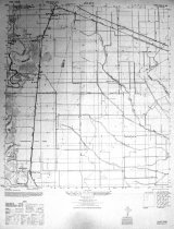
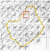
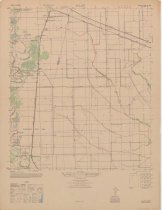
Map 1946 USGS 7.5-minute map Juliff, Texas quadrangle North arrow: yes North direction: top of map Compass bearings: no Scale: 1:24,000 Civil: - Arcola (not labeled) - Darrington State Farm - Fort Bend County (Partial) - Hawdon - Iowa Colony - Juliff - Mt. Tabor Church (no longer extant) - Mustang School (no longer extant) - Pleasant Grove Church (no longer extant) - Prison Cemetery - Sandy Point - Sandy Point Cemetery - School No. 20 (no longer extant) - St. Phillip Church (no longer extant) - Woods Cemetery (not labeled) Major waterways: - Bonner Slough (not labeled) - Briscoe Canal - Brushy Lake - Chocolate Bayou - Chocolate Bayou West Fork - Clear Lake - Hayes Creek (not labeled) - Jackson Lake (not to be confused with Lake Jackson) - Lake Sienna - Lawson Lake - Oyster Creek - Sugarhouse Lake - Thompson Lake - Willow Lake Major transportation infrastructure: - Airline Road (now CR 48 and CR 56) - CR 54 (not labeled) - Croix Road (now CR 81) - Missouri Pacific Railway (no longer extant) - Rifle Range Road (now CR 57) - Santa Fe Railway (now BNSF) - SH 288 (now FM 521) - SH 6 |
Subjects |
Airline Road BNSF Railroad Bonner Slough Briscoe Canal Brushy Lake Chocolate Bayou Chocolate Bayou West Fork Clear Lake CR 48 CR 54 CR 56 CR 57 CR 81 Croix Road Darrington Unit FM 521 Fort Bend County (Partial) Hawdon Hayes Creek Iowa Colony Jackson Lake (not to be confused with Lake Jackson) Juliff Juliff, Texas quadrangle Lake Sienna Lawson Lake Missouri Pacific Railway Morris Ave Mt. Tabor Church Oyster Creek Pleasant Grove Church Prison Cemetery Rifle Range Road Sandy Point Sandy Point Church Sandy Point Oil Field Santa Fe Railway School No. 20 SH 288 SH 6 South Texas Water Company Canal St. Phillip Church Sugarhouse Lake Thompson Lake USGS 7.5-minute map Willow Lake |
Date |
1946 |
Dates of Creation |
1946 |
Year Range from |
1942 |
Year Range to |
1946 |
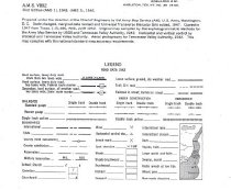
Extent of Description |
22" wide x 29" high |
Collection |
Transfer from Library Collection |
Accession number |
2009.013c |
Old ID number |
Library 96.70.01 |
Source |
Transfer from Library Collection |
Lexicon category |
8: Communication Artifact |
Catalog date |
2009-08-28 |
Catalog type |
Archive |
Imagefile |
023\2009.013c.0001-1.jpg |
Number of images |
5 |