
Archive Record
Images
Metadata
Object Name |
Map |
Catalog Number |
2013.015c.0021 |
Title |
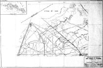
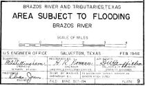
Map - Brazos River and Tributaries, Texas - Areas Subject to Flooding. |
Search Terms |
Alvin Angleton Austin Bayou BNSF Railway Brazos River Brazos River Tributaries Bushy Bayou CenterPoint Chocolate Bay Chocolate Bayou Danbury Oil Field Dow Chemical Company Ethylene pipeline Flooding. Flores Bayou gas pipeline Houston Lighting & Power Humble Pipeline Gulf Intracoastal Waterway Liverpool Mustang Bayou Persimmon Bayou Power Line Rowan Oil Field SH288 SH35 Sulfur Mine Sulphur Mine Texas Pipeline U.S Engineer Office, Galveston, Texas, Feb 1946 US6 West Bay |
Scope & Content |
Map - Brazos River and Tributaries, Texas - Areas Subject to Flooding. Diazotype whiteprint North arrow: yes North direction: left side of map Compass bearings: no Scale Graphic (scales at 1" = 1.051 mile) Scale unit: miles. ------------ PARTIAL TRANSCRIPT OF TITLE BLOCK --------------- Brazos River and Tributaries, Texas Areas Subject of Flooding - Brazos River Scale of miles. U.S Engineer Office, Galveston, Texas, Feb 1946 To accompany Survey Report on Brazos River Dated ___ ----------------------------------------------------------------------------------------- Area encompassed by this map: - North boundary: 29-30-00 N - East boundary: 95-07-30 W - South boundary: 29-07-30 N (Match Plate 8) - West boundary: West of 95-22-30 (Match Plate 10) |
Date |
February, 1946 |
Dates of Creation |
February, 1946 |
Extent of Description |
42" wide x 30" high |
Collection |
Munson Collection |
Accession number |
2013.015c |
Other number |
BRAZ 503-194 Plate 9 |
Source |
Munson Collection |
Credit line |
Munson Collection |
Lexicon category |
8: Communication Artifact |
Catalog date |
2013-07-23 |
Catalog type |
Archive |
Imagefile |
037\2013015c0021.JPG |
Number of images |
2 |